Kagoshima · Satsumasendai / KoshikishimaNo.881★★Open in map →
Koshikishima Islands
— an island chain off Satsumasendai
Three inhabited islands in the sea west of Satsumasendai, reached by high-speed boat or car ferry. Since a bridge closed the last strait, the chain can be driven end to end instead of hopped between by boat.
- FromSendai Port, Satsumasendai
- ~50 minHigh-speed boat, then a car
- Get off atSato Port, Kami-Koshiki Island
- From there
- Koshikishima Islands
The sweet spot
Koshikishima is genuinely off the usual routes. There is no airport and no railway, and the sailing schedule sets the shape of the day. It is not so much undiscovered as awkward to reach, which is why the islands stay uncrowded even now that a road runs the length of them.
Where it is
13 more notes in Kagoshima · open the map →What to look for — in walking order
- Sato, Kami-Koshikithe port village where the boat from the mainland lands, and the start of the island road
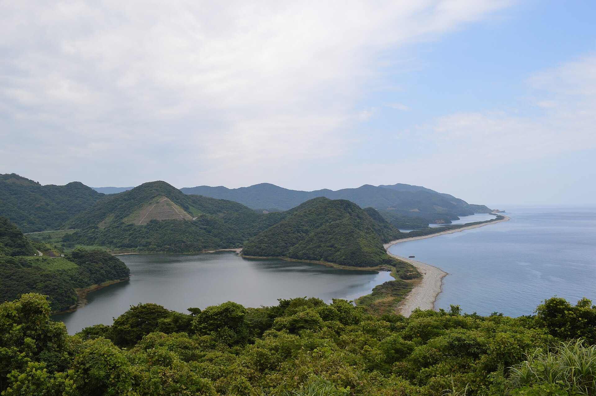
- Nagame-no-hamaa sandbar on the north coast walling off three lagoons — Namako, Kai and Kuwazaki ponds
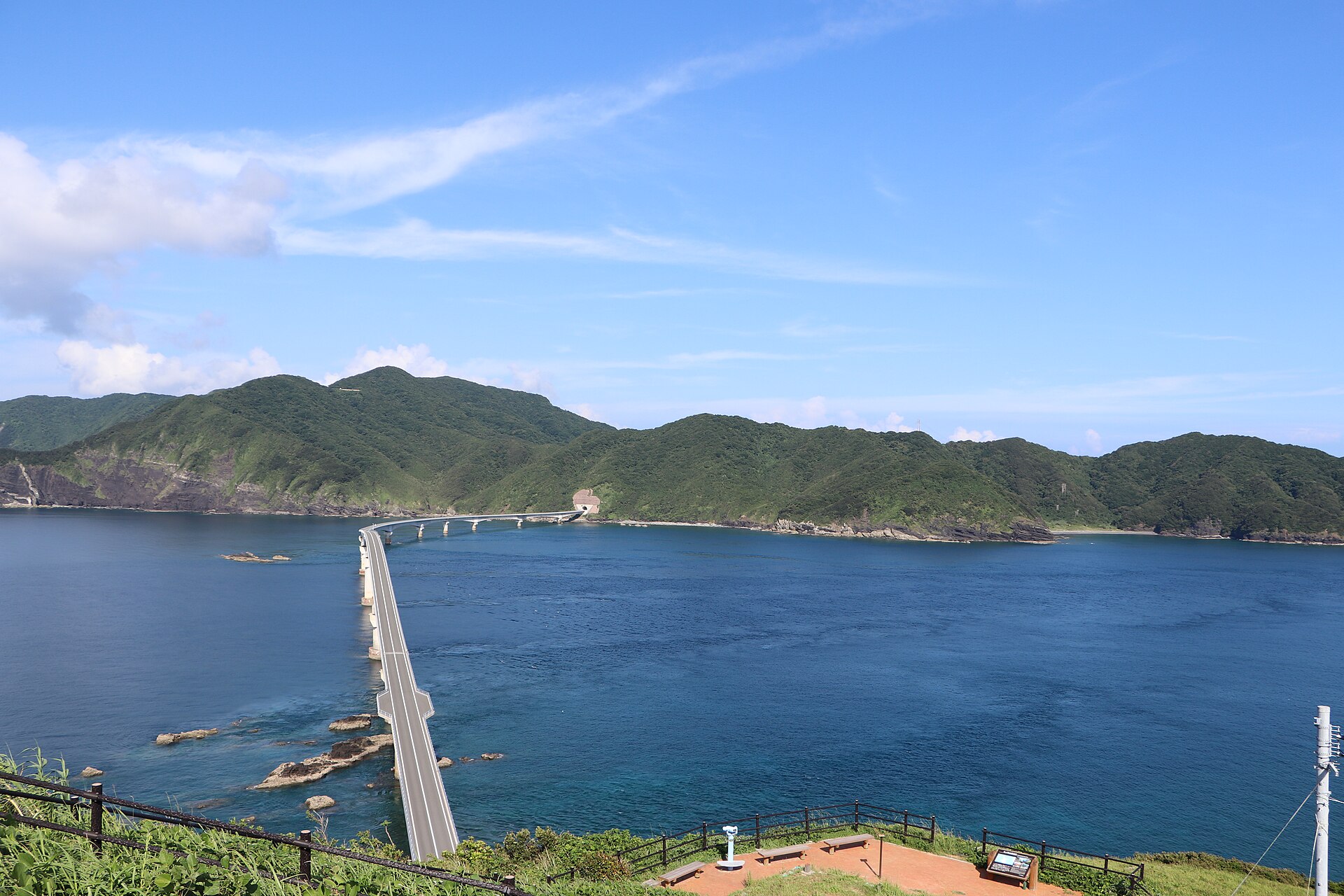
- Koshiki Ohashithe bridge over the Imuta Strait, the span that turned three islands into one drive
- The Kashima cliffsa wall of sea cliff on Shimo-Koshiki, counted among Japan's hundred geological sites
- Napoleon Rocka sea stack off the west coast of Shimo-Koshiki, named for the profile it cuts
How to actually get there
- Sendai Port → Sato Port, Kami-Koshiki (high-speed boat Koshikishima, about 50 min).
- Sato → south by road through Kami-Koshiki and Naka-Koshiki, over the two earlier bridges.
- Cross Koshiki Ohashi to Shimo-Koshiki, then on to the Kashima cliffs and the Napoleon Rock lookout.
- High-speed boat Koshikishima from Sendai Port
- From Satsumasendai, the high-speed boat Koshikishima crosses from Sendai Port to Sato on Kami-Koshiki in about 50 minutes. There are only a few sailings a day, so fix the outbound and the return together before you travel. The fast boat carries passengers; a car has to come on the ferry.
- Return sailing from Sato to the mainland
- The same high-speed boat runs back from Sato to Sendai Port. Departures are few and the last one leaves well before the evening, so drive the day around it. If the weather turns, sailings are cancelled outright rather than delayed, and the next chance may be the following day.
About the place
The Koshikishima chain lies west of the Satsuma mainland: Kami-Koshiki, Naka-Koshiki and Shimo-Koshiki, with a scatter of uninhabited rocks around them. The two northern islands had been bridged for years. The strait between Naka-Koshiki and Shimo-Koshiki had not, and crossing it meant a separate boat. Koshiki Ohashi closed that gap with a span of 1,533 metres, the longest bridge in Kagoshima Prefecture, and the three islands became one road. The result is a group you can drive in a day: lagoons and a sandbar on the northern island, sea cliffs and stacks on the southern one, and open water between them.
How to enjoy it
Sailings decide the day. The high-speed boat from Sendai Port reaches Sato in about 50 minutes and the car ferry from Kushikino takes about 75, so an early crossing and a late return is what makes a single day work. Take the ferry if you want your own car with you on the islands.
Background & history
The islands were administered from the Satsuma mainland and lived by fishing, and for most of their history the only way between the northern and southern halves was over water. Kagoshima Prefecture built the crossing in stages, and the final span opened to traffic on 29 August 2020. The rock the road now runs across is old sea floor: the cliffs of Shimo-Koshiki have yielded dinosaur fossils, among them the first ceratopsian remains identified in Japan.
Before you go
- Cash
- Tickets are bought at the port terminals and cash is the safe assumption. The bridge, the cliffs and the lookouts cost nothing. Shops and fuel are thin once you leave the two main villages, so stock up in Sato.
- Before you go
- Crossings are cancelled in rough weather, and in typhoon season the islands can be cut off for a day or more — leave slack in the plan. There is no railway and bus services are sparse, so a car is close to essential.
- Another way
- The car ferry New Koshiki runs from Kushikino Port in Ichikikushikino to Sato in about 75 minutes and takes vehicles, which is the practical way to bring your own car.
- After you get off
- Sato Port is at the northern end of the chain and the bridge at the far southern end of Naka-Koshiki, so this is a drive rather than a walk. Arrange a car, or a rental waiting at the port, before you sail.